Inventaires en ligne
Notice descriptive
- Cartes et plans

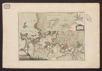
Harbours of L'Orient and Port-Louis/The coast from Quiberon to Port-Louis / Jefferys (T.). Graveur
Cote : 1 Fi 32/3
Description :
Plan anglais de la rade de Lorient et Port-Louis et carte de la côte de Lorient à Belle-Ile en encart.
Année de publication : [1740-1770]
Description matérielle : 1 plan
Notes :
Carte ayant pu être datée du XVIIIe siècle grâce au nom du graveur "T. Jefferys".
Sujet : Port
Lieu : Lorient (Morbihan, France) / Port-Louis (Morbihan, France)
Personne : Jefferys, Thomas (1719?-1771)
Type de document : Plan